Introduction
Introduction
There were many Native American tribes that called North America home. I bet you have heard of different tribes such as the Iroquois or the Cherokee, but do you know where they lived or what their environment was like? As researchers, we want to learn about these Native American tribes and the regions in North America they inhabited. In groups, you will be responsible for a tribe in one specific region. Each student will fill out a chart based on the information found and then create a poster as a group to share what they have learned with the class!
- Southwest region will explore the Pueblo.
- Great Plains region will explore the Apache.
- Northeastern Woodlands region will explore the Iroquois.
- Southeastern Woodlands region will explore the Cherokee.
- Northwest Coast region will explore the Chinook.


Task
Task
Each student will work independently to find the information needed for the chart. After filling out your chart with the information found in the links I have provided, you will then create a poster of your region. This poster must include the information you wrote down on your chart, a historical map of where your tribe lived, and 3 pictures (printed out or drawn) that represent your region and/or tribe.
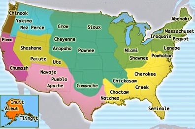
(Historical map of Native American tribes in the United States)
Table A: Region: Southwest/Pueblo
https://www.warpaths2peacepipes.com/native-american-indians/southwest-native-americans.htm
http://www.bigorrin.org/pueblo_kids.htm
https://www.warpaths2peacepipes.com/native-american-indians/native-american-map.htm
Table B: Region: Great Plains/Apache
https://www.warpaths2peacepipes.com/native-american-indians/great-plains-indians.htm
http://www.bigorrin.org/apache_kids.htm
https://www.warpaths2peacepipes.com/native-american-indians/native-american-map.htm
Table C: Region: Northeastern Woodlands/Iroquois
https://www.warpaths2peacepipes.com/native-american-indians/woodland-indians.htm
http://www.bigorrin.org/iroquois_kids.htm
https://www.warpaths2peacepipes.com/native-american-indians/native-american-map.htm
Table D: Region: Southeastern Woodlands/Cherokee
https://www.warpaths2peacepipes.com/native-american-indians/southeast-native-americans.htm
http://www.bigorrin.org/cherokee_kids.htm
https://www.warpaths2peacepipes.com/native-american-indians/native-american-map.htm
Table E: Region: Northwest Coast/Chinook
https://www.warpaths2peacepipes.com/native-american-indians/northwest-native-americans.htm
http://www.bigorrin.org/chinook_kids.htm
https://www.warpaths2peacepipes.com/native-american-indians/native-american-map.htm
Please write your notes on this chart.
https://docs.google.com/document/d/1SJHuOf0S3C5Q66Xzf_mnttMvY8S7fzy98vRf23ZLe58/edit?usp=sharing
Process
Process
Step 1: Each table will be given a specific region/tribe they will be researching.
-
Check back at the task tab for your assigned region/tribe.
Step 2: Each student will be given a chart to fill out during their research.
Step 3: Research your tribe with the links provided and fill out all the information on your chart.
-
Check back at the task tab for your links.
Step 4: Come together as a group to make a beautiful poster!
-
Make sure you include a historical map of where the tribe was located AND 3 pictures (either hand drawn or printed from the internet).
These posters will be displayed around the room and each group will have a chance to learn about each tribe!
Evaluation
Evaluation
Native Americans and their Regions Rubric
|
CATEGORY |
4 |
3 |
2 |
1 |
|
Matrix |
Information for all 5 categories and questions. |
Information for 4 categories and questions. |
Information for 3 categories and some questions. |
Information for 2 categories or less. |
|
Required Elements |
The poster includes all required elements as well as additional information. |
All required elements are included on the poster. |
All but 1 of the required elements are included on the poster. |
Several required elements were missing. |
|
Attractiveness |
The poster is exceptionally attractive in terms of design, layout, and neatness. |
The poster is attractive in terms of design, layout and neatness. |
The poster is acceptably attractive though it may be a bit messy. |
The poster is distracting, messy, or very poorly designed. |
|
Use of Class Time |
Used time well during each class period. Focused on getting the project done. Never distracted others. |
Used time well during each class period. Usually focused on getting the project done and never distracted others. |
Used some of the time well during each class period. There was some focus on getting the project done but occasionally distracted others. |
Did not use class time to focus on the project OR often distracted others. |
Conclusion
Conclusion
I hope you had a great time exploring the Great Plains, Northwest Coast, Eastern Woodlands, Southeast, and Southwest regions! At the end of this lesson you have mastered where your tribes settled using a historical map, the geography of each location, and how they interacted with their environment. You have also learned these facts for all the different regions your classmates researched! These posters will be displayed in the hallway for all other students to explore! Great job class!
Credits
Credits
- All information gathered for this project can be found
https://www.warpaths2peacepipes.com/native-american-indians/native-american-map.htm
http://www.bigorrin.org/pueblo_kids.htm
https://www.warpaths2peacepipes.com/native-american-indians/great-plains-indians.htm
http://www.bigorrin.org/apache_kids.htm
https://www.warpaths2peacepipes.com/native-american-indians/northwest-native-americans.htm
https://www.warpaths2peacepipes.com/native-american-indians/woodland-indians.htm
http://www.bigorrin.org/iroquois_kids.htm
http://www.bigorrin.org/cherokee_kids.htm
https://www.warpaths2peacepipes.com/native-american-indians/southwest-native-americans.htm
http://www.bigorrin.org/chinook_kids.htm
https://www.warpaths2peacepipes.com/native-american-indians/southeast-native-americans.htm
- All pictures gathered for this project can be found
http://www.directexpose.com/native-american-history-facts/
https://www.warpaths2peacepipes.com/native-american-indians/native-american-map.htm
Permissions
We all benefit by being generous with our work. Permission is granted for others to use and modify this WebQuest for educational, non-commercial purposes as long as the original authorship is credited. The modified WebQuest may be shared only under the same conditions. See the Creative Commons Attribution • Non-Commercial • Share-Alike license for details.
Teacher Page
Teacher Page
By Allison Corda
This WebQuest was designed for 5th grade students to immerse themselves in the geography and how the Native Americans lived relating to their environment.
Standards used:
6.1.8.B.1.a
6.1.8.B.1.b