Introduction
Welcome to the virtual fieldwork that looks at the part of the Georges river flowing through the suburb of Liverpool alongside Heathcote road.This area is the main focus of the field work.The case study of the area will be used to assist you in completing the activities.After completing all the tasks ,you should be familiar with understanding the physical characteristics of an Australian landforms and its physical envirnoment.
Have fun
Task
Congratulations on your selection of being an expert in geography.As part of the training process you are required to undertake a virtual fieldtrip on Georges river in Liverpool and anaylse the physical characteristics of this famous land form.In addition, you have to find the reponses and impacts of floods from this river has on the people living in the surrounding areas and also the impact humans have on the river.Enjoy.

Process
Lesson 1
Open Website : http://www.georgesriver.org.au/Natural-Environment.html
After going through the website, open a word document and answer the following:
- Where does the river start and where it ends?
- How long is Georges river?
- Its longitude and latitude?
- How far from the origin is Liverpool?
- List three vegatation communities present in the river?
- List three types of faunas found in the region?
Find a map of the river from google maps. Copy the map and paste it in a word document titled the "River Profile".Highlight the Liverpool portion of the river.Using Google Earth and the Website create a profile of Georges River below the map.
The profile should contain:
- Location
- Length
- Origin and destination
- Suburbs it flows through
Please make sure to save your document .
Lesson 2
Watch the following videos
Using the information from the video answer the following questions on a word document.
- What physical features you can identify near the river?
- What does the surrounding tell you about the climate?
- Can you identify any man made structures around the river?
- What do you see and hear in the surrounding areas?
- What types of animal sounds you can hear?Can you identify any?
- Can you identify any faunas?
- List at least three vegtation communities found around Geroges river?
Using the information from the videos above construct a sketch of the river on a word document.Note the things you see in the videos.Try to include the things you mentioned in the answers.
Please save your documents.
[video:https://www.youtube.com/watch?v=4Vjk8KYwo4M]
[video:https://www.youtube.com/watch?v=Zq1YMMe61YI ]
Recomended site
http://www.georgesriver.org.au/Natural-Environment.html
One of the major natural hazards concerning the river systems is flooding.Floodings in Georges river is common.Watch the video on floods and answer the following.
[video:https://www.youtube.com/watch?v=1t_WWMgqVko]
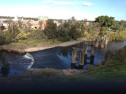
Lesson 3
Watch the following video
[video:https://www.youtube.com/watch?v=xuWYfgQd8u4]
Open a word document and answer the following questions from the information.You can also use the recommended website provided.
- What year was the weir constructed?
- Why was it constructed?list at least two reasons.
- What benefical impact did the construction have on the people?
- Please make sure to save your document
Recomended site
[video:http://www.georgesrivereec.com.au/tour/8.htm]
[video:https://www.youtube.com/watch?v=jhowEemG5UY]
[video:https://www.youtube.com/watch?v=aLptF4p9fIE]
Determine the rainfall data for the Liverpool area.Your findings should include :
- In which month and year was the highest rainfall in Liverpool?
- What is the average annual rainfall?
- How frequently are the floods happening?
- What is a flood?
- What are three types of flooding?
- What is the main cause of flooding?
- how do humans contribute to flooding?
Answering these questions will provide you with the crucial information about the rainfall in the Liverpool region which is the major cause of flooding.Please make sure to save your document.
Recomended website:
http://www.weatherzone.com.au/climate/station.jsp?lt=site&lc=67035
Lesson 4
Browse through this website and view the videos
http://www.9news.com.au/national/2015/04/21/05/54/nsw-coast-lashed-by-w…
Watch the videos.Open a word document and answer the questions.
[video:https://www.youtube.com/watch?v=LQxsZ5IV3Zw]
- How does it affect the people?
- What impact does flooding have on the economy?use examples
Using the information obtained so far construct a concept map illustrating the causes and impacts of flooding.You can use C- maps or a word document to construct your concept map.Please make sure to save your document.
Recommended site
Governments play a major role in the infrastructure of the city.In a word document write the responses to the following.
- What actions the government is taking in order to prevent floods in the georges river?
Using the recomended websites find:
- Look for newspaper articles or news clips in regards to the issue.
- Check if any improvements have been made.
Recomended sites
http://www.georgesriver.org.au/State-and-Federal-Government.html
http://www.liverpool.nsw.gov.au/environment/water-and-waterways/flood-m…
Evaluation
| Marking Rubric 0-25 | Fail 0-12 | Pass 13-16 | Credit 17-19 | Distinction 20-22 | High distiction 23-25 | |
|
Extracting information from website and creating river profile |
Poor attempt in creating river profile Lack of information provided |
Basic attempt in creating river profile. Needs more information |
Satisfactory attempt in creating river profile Bit more details required |
Good attempt in creating river profile More in depth information reqired |
Excellent attemp in creating river profile. Solid understanding of the concept |
|
|
Understanding and description of the historical context of the liverpool weir |
Poor descrition of the weir and its context |
Basic descrition of the weir and its context | Satisfactory descrition of the weir and its context | Good descrition of the weir and its context | Excellent descrition of the weir and its context | |
|
Creating field sketches of the fieldwork from information provided in the visual components |
Poor excecution of the sketch |
Basic excecution of the sketch | Satisfactory excecution of the sketch | Good excecution of the sketch | Excellent excecution of the sketch | |
|
Construction of concept maps and proper use of ICT |
Poor construction of the concept map requires more attention | Basic construction of the concept map requires more attention | Satisfactory construction of the concept map requires a bit more attention | Good construction of the concept map requires more in depth attention | Excellent construction of the concept map | |
|
Description and understanding of relationship between humans and natural environments |
Poor understaning of the relationship between humans and natural enviroments | Basic understaning of the relationship between humans and natural enviroments | Satisfactory understaning of the relationship between humans and natural enviroments | Good understaning of the relationship between humans and natural enviroments | Excellent understaning of the relationship between humans and natural enviroments |
Conclusion
Finally, you have completed your virtual field trip of Georges River.You should now have relevant understanding of the Australian landform and its relatioships with humans.Check the responses of your answers and make sure you have saved all the required documents including your sketches and concept maps.
Rememeber Geography is a study of of people and their enviroments.Please submit all your work.
Hope you had fun learning about rivers and its relationship with the people.
Good luck.
Credits
This lesson was created by Anand krishna 17057051
Teacher Page
Thankyou for taking part in the virtual fieldtrip.This lesson was subjected to the requirements of Year 9/ Stage 5 of the geography syallabus provided by the Board of Studies. .The main focus of the lesson was to teach and assess Year 9 students undertaking geography on their ability to follow instructions.The use of ICT component in this lesson was used to assess students reponsiblity towards their tasks and showcase the use of ICT resouces for assignments.You can now have fun creating your own webquest to enhance your learning. Enjoy.