Introduction

Earthquakes can be a really scary thing. Earthquakes can happen at any time and any place. Stronger earthquakes can cause tsunami's, landslides, and flooding.Let's take a look and see how they form and how they work.
What is an Earthquake?
An earthquake is a sudden shock of the earth's surface. This happens when two large pieces of the earth's crust suddenly slip. The slip causes shock waves to shake the surface of the earth. Earthquakes are a way the earth relieves some stress.
What causes an Earthquake?
There are things called tectonic plates that run along the surface of the earth. They are always moving about and pushing into each other. When they are moving around, sometimes they get squeezed or stretched and when this happens, rocks form around the edges. The rocks then move with so much force, and when this happens we get an earthquake. The force is very strong and sends out seismic waves, and this is exactly what an earthquake is, the earth starts shaking and this might cause buildings to fall, tsunami's to rise, and other catastrophic events.

How do scientists measure how strong an earthquake is?
It is very important for scientist to be able to record, and detect earthquakes. To know this, scientists use a seismograph. A seismograph is a piece of equipment that records detailed information about earthquakes such as how long the earthquake lasted to how much force the earthquake had.

Where in the United States do Earthquakes occur the most?
It is called California's sleeping giant, The San Andreas Fault is the most famous fault in the world. It is where most earthquakes occur. The San Andreas fault is the marks a boundary between two of earth's tectonic plates. The biggest earthquake in California happened along this boundary.
Task
How to Make a Salt Map
To build an example of a Salt Map or a tectonic plate project, one can be built with different colored playdough or even with ingredients found in our kitchens. (ie. Google salt map) The playdough can be used to create lithospheric plates and tectonic plate boundaries. This can provide a great method to display the tectonics plate theory.
The state of California is known for earthquakes, especially Los Angeles and San Francisco. These two cities sit on or are near the San Andreas Fault. The San Andreas Fault is a formation created by moving plates that meet in Western California. The Pacific Plate moves westward in relation to a North American plate on the east. These two moving plates have been moving slowly toward each other for millions of years, causing earthquakes along the fault.

Process
How to make a Salt Map:
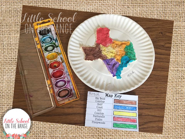
This project is best in groups and with adult supervision. The purpose of Salt Map is to show the audience where earthquakes happen the most. Students will have to mark places that earthquake occurred in the past and will paint in the faults of the state.
Materials:
- Salt
- Flour
- Water
- Paper Plates
- Paint
Instructions:
- Mix the salt and flour.
- Add water slowly and mix until the dough has the consistency of play dough. (add more flower if too watery or add more water if too powdery)
- The paper plates will be used as the base of the dough.
- On the paper plate, trace the state or country of your choice. (For Earthquake purposes, we will trace the state California, where many earthquakes has taken place.)
- Mold the dough on the plate in the shape of the state.
- Let it dry for about to days, then start painting the region where Earthquakes mostly appeared.
https://littleschoolontherange.blogspot.com/2016/01/salt-dough-maps.html
Evaluation
|
|
POOR 1pt |
FAIR 4pts |
EXCELLENT 5pts |
|
Follow directions |
Not following directions in which to do the project |
Followed most instructions for the project |
Followed all directions |
|
Built Tectonic plate |
Not using the proper tools to create the tectonic plate |
Used most of the tools for the tectonic plate and being creative |
Used all the proper tools for the tectonic plate and being creative |
|
|
|
Total score= |
|
On a scale from 1-3. One being not likely and three being likely.
A) Was the project difficult to make?
1-not likely
2-unsure
3-likely
b) would you share to others what you learned about earthquakes and tectonic plates?
1-not likely
2-unsure
3-likely
c) Did you enjoy making the Tectonic plate project?
1-not likely
2-unsure
3-likely


Conclusion
All and all earthquakes are apart of mother nature and this phenomenon is something we can not stop!
You have learned the basics of earthquakes of:
What is an earthquake? How they are formed? and How to detect an earthquake!
*One thing to always remember is safety is key in all aspects*

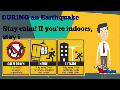
- TAKE COVER
- COVER YOURSELF WITH OBJECT TO KEEP YOU SAFE
- AND TUCK DOWN TO YOUR KNEES TO PROTECT YOU HEAD